You are here: City posts —>
The boundary marks today —>
Individual boundary marks —>
Post 156
- Status:
Extant
- Type:
2e
- National grid reference:
TQ2411356546
- Location:
On E side of footpath 230 m N of Bonsor Drive, S of former (now disused) Brighton Road entrance to Red House
- Location map at Streetmap:
TQ2411356546
- Original 19th century parish:
Banstead
- Depicted on first edition of OS 6" map as:
B.P.
- Moved:
No
- Circumstances of move:
n/a
- New national grid reference:
n/a
- New location:
n/a
- Map of new location at Streetmap:
n/a
- Locality:
Kingswood
- Access:
On public footpath
- Listed building:
Grade II
- Local authority:
Reigate and Banstead
- Last seen:
02/04/2012
- Date missing:
n/a
- Notes:
Additional photographs of Post 156:
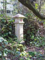
Post 156 in 2012
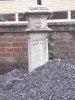
Post 156 in 1972
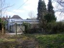
Post 156 in 2008
Link to photographs of Post 156
<— Previous mark |
Back up to Individual boundary marks |
Next mark —>
Page created by Martin Nail: Contact me. Last revised
15th April 2012
 This
web site: Copyright © 2012 Martin Nail. It is licensed under a Creative Commons
Attribution-Non-Commercial-Share Alike 2.0 UK: England & Wales License.
This
web site: Copyright © 2012 Martin Nail. It is licensed under a Creative Commons
Attribution-Non-Commercial-Share Alike 2.0 UK: England & Wales License.
 |
|
 |
|