You are here: City posts —>
The boundary marks today —>
Individual boundary marks —>
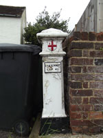
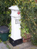
Post 34
- Status:
Extant
- Type:
2a**
- National grid reference:
TL2064305781
- Location:
N side of Coursers Road outside 'Greynam' 20 m SW of junction with High Street
- Location map at Streetmap:
TL2064305781
- Original 19th century parish:
Ridge
- Depicted on first edition of OS 6" map as:
City Post
- Moved:
No
- Circumstances of move:
n/a
- New national grid reference:
n/a
- New location:
n/a
- Map of new location at Streetmap:
n/a
- Locality:
Colney Heath
- Access:
Beside road
- Listed building:
Grade II
- Local authority:
St Albans
- Last seen:
13/06/2015
- Date missing:
n/a
- Notes:
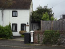
Additional photographs of Post 34:
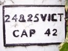
Correction plate on Post 34 in 2008
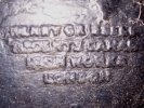
Maker's name on Post 34 in 2008
Post 34 in 2015
Post 34 in 2008
Link to photographs of Post 34
<— Previous mark |
Back up to Individual boundary marks |
Next mark —>
Page created by Martin Nail: Contact me. Last revised
19th June 2015
 This
web site: Copyright © 2015 Martin Nail. It is licensed under a Creative Commons
Attribution-Non-Commercial-Share Alike 2.0 UK: England & Wales License.
This
web site: Copyright © 2015 Martin Nail. It is licensed under a Creative Commons
Attribution-Non-Commercial-Share Alike 2.0 UK: England & Wales License.
 |
|
 |
|