You are here: City posts —>
The boundary marks today —>
Individual boundary marks —>
Post 33
- Status:
Moved
- Type:
2c
- National grid reference:
TL2055804949
- Location:
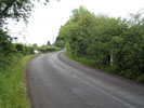
E side of Coursers Road at bend N of Coursers Farm
- Location map at Streetmap:
TL2055804949
- Original 19th century parish:
Ridge
- Depicted on first edition of OS 6" map as:
City Post
- Moved:
Yes
- Circumstances of move:
Re-erected 2015 on opposite side of road having been knocked over by a car in 2012
- New national grid reference:
TL2055404954
- New location:
W side of Coursers Road at bend N of Coursers Farm
- Map of new location at Streetmap:
TL2055404954
- Locality:
Colney Heath
- Access:
Beside road
- Listed building:
Grade II
- Local authority:
St Albans
- Last seen:
13/06/2015
- Date missing:
n/a
- Notes:
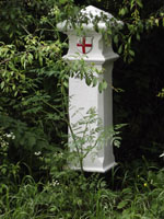
Additional photographs of Post 33:
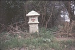
Post 33 in 1972
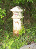
Post 33 in 2008
Post 33 in 2012
Post 33 in 2015
Link to photographs of Post 33
<— Previous mark |
Back up to Individual boundary marks |
Next mark —>
Page created by Martin Nail: Contact me. Last revised
18th August 2018
 This
web site: Copyright © 2015 Martin Nail. It is licensed under a Creative Commons
Attribution-Non-Commercial-Share Alike 2.0 UK: England & Wales License.
This
web site: Copyright © 2015 Martin Nail. It is licensed under a Creative Commons
Attribution-Non-Commercial-Share Alike 2.0 UK: England & Wales License.
 |
|
 |
|