The boundary
The boundary
This list contains 211 marks which are currently extant, including some which been moved to new locations or are in museums.
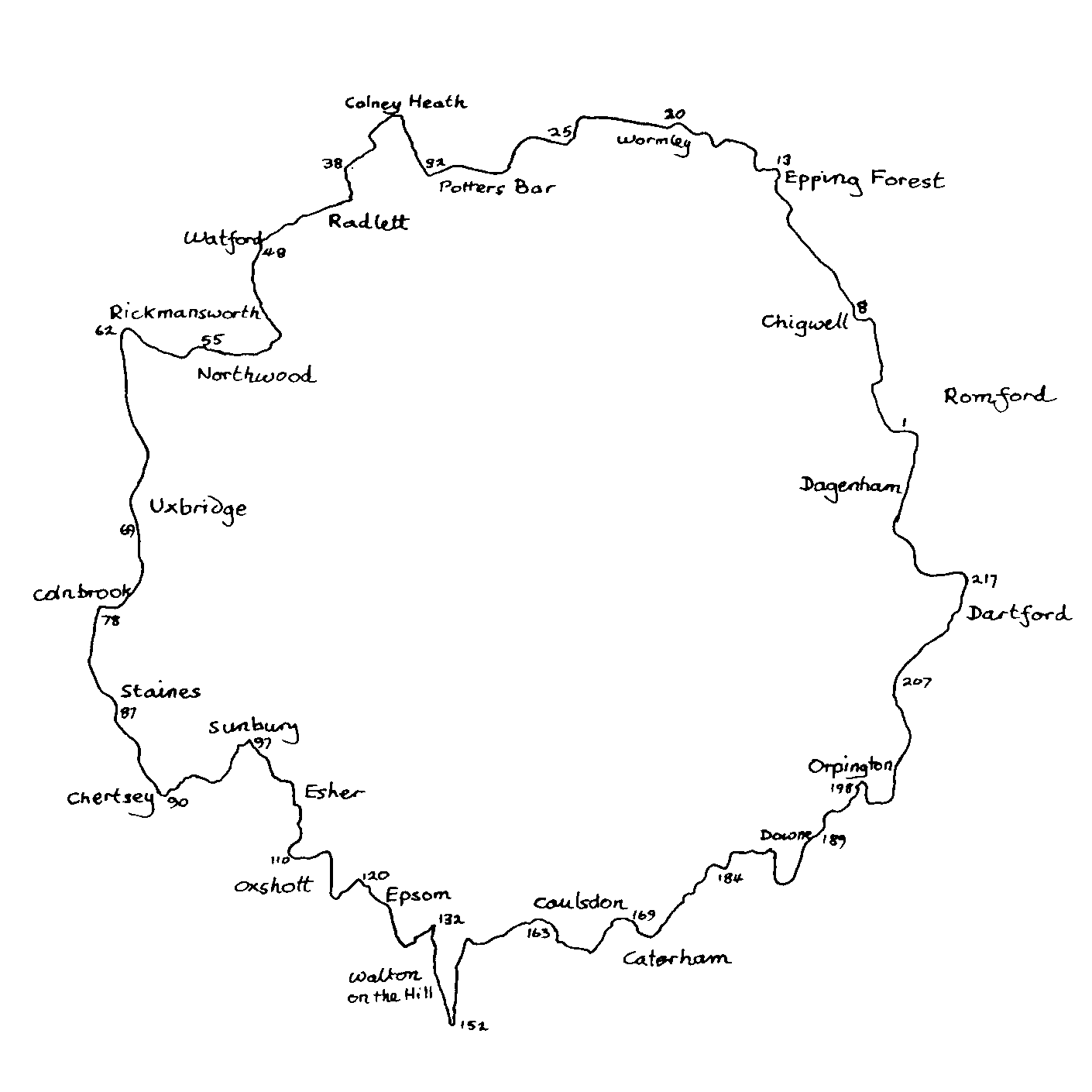
The list is arranged topographically, following the boundary anticlockwise from Dagenham to Crayford Ness. The sketch map is a guide to the approximate location of the various marks. The number in the first column below is to aid reference to the list and is explained in numbering of the marks. The type of boundary mark is given in second column. For each mark also a description of its location and accessibility and its National Grid Reference are given.
Where a mark is no longer in its original location this is noted in the Location column: marks are only noted as having been moved where it is certain that they have been moved and where they have been moved a significant distance.
The list is also available to download as a PDF file: Extant_Posts_Report.pdf (183 KB). This is an updated version (v7) of the file, dated 6th February 2021.
The list does not include the Obelisk at Gravesend as I am currently undecided as to whether it should count as a coal duty boundary marker.
| No | Type | NGR | Location |
|---|---|---|---|
| 1 | 2d | TQ5091487335 | W side of Dagenham Road, 80 m S of Rush Green Road, outside No 98 Access: Beside road |
| 2 | 2 | TQ4982187070 | S side of Wood Lane 15 m E of Wisdons Close, W of bridge over culverted stream Access: Beside road |
| 3 | 4a | TQ4897487830 | N side of railway 300 m E of Whalebone Bridge, to rear of No 334 Crow Lane Access: On railway land but visible from Crow Lane |
| 4 | 2d | TQ4895788200 | S side of London Road outside No 403 Access: Beside road |
| 5 | 2d | TQ4804486532 | On display outside Valence House Museum, Valence Park, Becontree Avenue, to left of front door Originally at: TQ4844988679 E side of Whalebone Lane North at NW corner of grounds of Warren Comprehensive School. Moved following road widening in 1960. Access: During opening hours of Valence Park |
| 6 | 2 | TQ4882890747 | S side of Collier Row Road in grounds of Abbey Care Home Access: In forecourt of house but visible from road |
| 7 | 2d | TQ4888491091 | S side of Romford Road opposite No 70 Hog Hill Road Access: Beside road |
| 8 | 2 | TQ4726093811 | N side of Manor Road outside No 3 'Sheepcotes' Access: Beside road |
| 9 | 2c | TQ4589296282 | S side of London Road opposite No 126, 'The Chase' Access: Beside road |
| 10 | 4c | TQ4519997678 | SE side of railway N of Long Shaw, 950 m S of Green Glade bridge Access: On railway land but visible from train |
| 11 | 2d | TQ4457098370 | N side of Debden Lane opposite house called 'The Boundary' Loughton Lane Access: Beside road |
| 12 | 2c | TQ4316499447 | S side of Coppice Row on Jacks Hill, 450 m E of the Wake Arms roundabout Access: Beside road |
| 13 | 2c | TL4370100399 | E side of Epping Road 140 m N of junction with Crown Hill, by Ambresbury Banks Access: Beside road |
| 14 | 2f | TL4076604443 | NE end of Galley Hill Green, 340 m S of end of metalled portion of Bumbles Green Lane Access: On public bridlepath |
| 15 | 2g | TL4058304873 | S side of Waltham Road, 140 m W of Allmains Close Access: Beside road |
| 16 | 2c | TL3932203983 | N side of Holyfield Road just W of junction with St. Leonards Road Access: Beside road |
| 18 | 2g | TL3893204370 | W of stile leading to Lousehall Lane on S side of Colemans Lane 300 m W of St. Leonards Road Access: Beside road |
| 19 | 2f | TL3880504443 | S side of Colemans Lane 50 m W of 'Valley View' Access: On public footpath |
| 20 | 1 | TL3725705017 | W side of Lee Navigation 120 m S of Kings Weir at end of Slipe Lane Access: Beside towpath |
| 21 | 4c | TL3685905126 | E side of railway, N side of Slipe Lane at level crossing Access: On public footpath |
| 22 | 2* | TL3648405231 | E side of High Road, Turnford, outside No 137 Access: Beside road |
| 23 | 2c | TL3429805782 | E side of Holy Cross Hill, opposite footpath to Biggs Grove, 400 m NE of junction with Beaumont Road Access: Beside road |
| 24 | 2h | TL3227005766 | In Wormley Wood, 800 m NNW of Tanfield Farm Access: On permissive path in public access land |
| 25 | 2c | TL3081804672 | N side of Darnicle Hill, at E end of Newgate Street Bridge Originally at: TL3081404665 S side of Darnicle Hill, E of Newgate Street Bridge. Re-erected 2011 on opposite side of road having been knocked over by a car in 2008. Access: Beside road |
| 26 | 2* | TL2709003424 | N side of Ridgeway at junction with Shepherds Way and Well Road Access: Beside road |
| 27 | 2c | TL2705903196 | W side of Well Road, S of exit from Queenswood School Access: Beside road |
| 28 | 2c | TL2609202116 | W side of Hatfield Road, by side fence of No 139 Church Road 30 m S of Church Road Access: Beside road |
| 29 | 2c | TL2604802138 | S side of Church Road, 40 m W of Hatfield Road outside No 135 Access: Beside road |
| 30 | 2c* | TL2570202398 | N side of Heath Road, 100 m W of Osborne Road outside No 57 Access: Beside road |
| 31 | 4c | TL2431702736 | E side of railway, 400 m S of Hawkshead Bridge Access: On railway land but visible from public footpath on opposite side of railway |
| 33 | 2c | TL2055404954 | W side of Coursers Road at bend N of Coursers Farm Originally at: TL2055804949 E side of Coursers Road at bend N of Coursers Farm. Re-erected 2015 on opposite side of road having been knocked over by a car in 2012. Access: Beside road |
| 34 | 2a** | TL2064305781 | N side of Coursers Road outside 'Greynam' 20 m SW of junction with High Street Access: Beside road |
| 35 | 2a | TL2059205818 | On Colney Heath, 20 m S of High Street, W of No 9 Access: On public access land close to road |
| 36 | 2z | TL1985505923 | N bank of River Colne, 15 m E of Church Lane Access: On public access land close to road |
| 37 | 2c | TL1819703678 | SW side of High Street, London Colney, on bridge approach N of the River Colne Access: Beside road |
| 38 | 2c | TL1755803216 | E side of Shenley Lane, S of River Colne at Broad Colney Bridge Access: Beside road |
| 39 | 2e | TL1720402305 | N side of Harper Lane, outside No 108 Access: Beside road |
| 40 | 2c | TL1740702486 | S side of Harper Lane, outside No 67 Access: Beside road |
| 41 | 2e | TL1764001434 | In hedgerow 350 m E of Margaret Cottages, 65 m S of footpath leading to Shenleybury Access: On private land but just visible from public footpath |
| 42 | 5 | TL1605600736 | W side of railway, 35 m N of the Avenue behind No 2 Marble Arch Cottages Access: On railway land but visible from road |
| 43 | 2c | TL1604400734 | E side of Watling Street, 30 m N of the Avenue, in front of No 2 Marble Arch Cottages Access: Beside road |
| 44 | 2c | TL1627400073 | W side of Watling Street, S of junction with Malt Lane, outside No 24 Access: Beside road |
| 45 | 4b | TQ1164396578 | W side of railway at five-arch viaduct, N side of footpath on N bank of River Colne in Waterfields Recreation Ground Originally at: TQ1165796562 W side of railway at five-arch viaduct, on S bank of River Colne. Re-erected in 1984 after lying in pieces at original site since 1961. Access: On public footpath |
| 46 | 2a | TQ1161596252 | S side of Water Lane, 50 m E of bridge over River Colne, Originally at: TQ1160996252 S side of Water Lane, E of bridge over former course of River Colne. Moved for road widening in 1966, and again in 2015. Access: Beside road |
| 47 | 2* | TQ1102896393 | Centre of New Street at junction with High Street Originally at: TQ1187395500 N side of Lower High Street at NW corner of Bushey Arches. Moved in 1968. Access: In road |
| 48 | 2c | TQ1101996382 | Centre of New Street at junction with Church Street Originally at: TQ1196295266 S side of Capel Road at junction with Pinner Road. Moved in 1968. Access: In road |
| 49 | 2e | TQ1307292575 | E side of Oxhey Lane, outside 'The Hollies' Access: Beside road |
| 50 | 5 | TQ1233892233 | W side of railway, 300 m S of Little Oxhey Lane Access: On railway land but visible from public footpath |
| 51 | 2e* | TQ1060791690 | E side of Potter Street Hill, outside The Lodge 10 m N of junction with South View Road Access: Beside road |
| 52 | 5 | TQ0917692069 | E side of railway, N of the Boundary Footpath 150 m W of Eastbury Road Access: On railway land but visible from public footpath |
| 53 | 2e | TQ0869792205 | In school grounds N of the Boundary Footpath, 170 m E of Kewferry Road Access: On private land but visible from public footpath |
| 54 | 2e | TQ0836092324 | N of the Boundary Footpath, 180 m W of Kewferry Road Access: Near public footpath |
| 55 | 2e | TQ0784192336 | W side of Rickmansworth Road, 40 m S of 'The Prince of Wales' Access: Beside road |
| 57 | 2e | TQ0656191697 | S side of Shrubs Road, 250 m NW of junction with Northwood Road Access: Beside road |
| 58 | 2e | TQ0583892242 | E side of Rickmansworth Road where it becomes Harefield Road outside High Lodge Access: Beside road |
| 59 | 2e | TQ0516992801 | E side of footpath from Cripps House Farm to Stockers Farm, 120 m N of Cooks Wood Access: On public footpath |
| 60 | 1 | TQ0466593220 | N bank of Grand Union Canal 500 m NE of Springwell Lock Access: Beside towpath |
| 61 | 2e | TQ0435093501 | N bank of River Colne, W of Shire Ditch, E of easternmost point of Inns Lake Access: On private land but visible from permissive footpath on other bank of river |
| 62 | 2 | TQ0404693538 | W side of Springwell Lane S of River Colne at Drayton Ford Bridge Access: Beside road |
| 63 | 3a | TQ3256083537 | In Museum of London reserve collections Originally at: TQ0404493541 W side of Springwell Lane in parapet of Drayton Ford Bridge. Removed in 1923 and in current ownership since 1965. Access: By appointment -- in museum store |
| 64 | 2e | TQ0467688045 | In front garden of Savay Farm House, Savay Lane Originally at: TQ0476988036 E side of River Colne by bridge at Savay Farm. Moved in 1962. Access: On private land but visible from road |
| 65 | 3b | TQ0510884620 | S side of Oxford Road in parapet of bridge over the River Colne Access: Beside road |
| 66 | 2e | TQ0460483517 | N side of St Johns Road by Long Bridge, W of junction with Cowley Mill Road Access: Beside road |
| 67 | 2* | TQ0492482226 | N side of Iver Lane W of River Colne at Clisby's Bridge Access: Beside road |
| 68 | 3b | TQ0491882221 | N side of Iver Lane W of River Colne in N parapet of Clisby's Bridge Access: Beside road |
| 69 | 1 | TQ0484680727 | S side of Slough Arm of Grand Union Canal, W of footbridge 75 m E of aqueduct over River Colne Access: Beside towpath |
| 70 | 4a | TQ0519680121 | N side of railway 20 m W of Colnbrook branch underbridge Access: On railway land but visible from permissive footpath |
| 72 | 2e | TQ0521179246 | N side of Mill Road E of bridge over Bigley Ditch Access: Beside road |
| 73 | 3b | TQ0520679248 | N side of Mill Road in parapet of bridge over Bigley Ditch Access: Beside road |
| 74 | 2* | TQ0092893845 | On display at Chiltern Open Air Museum, Chalfont St. Giles Originally at: TQ0405676856 On E bank of former course of Wyrardisbury River 200 m N of Madbridge (site now under M25 motorway). Removed in 1982 in advance of construction of M25 motorway and at current location since 1998. Access: When museum open |
| 75 | 2e | TQ0126994132 | On display at Chiltern Open Air Museum, Chalfont St. Giles Originally at: TQ0404876856 On W bank of former course of Wyrardisbury River 200 m N of Madbridge (site now under M25 motorway). Removed in 1982 in advance of construction of M25 motorway and at current location since 1998. Access: When museum open |
| 77 | 2e | TQ0278777038 | N side of Park Road, E of bridge over the Colne Brook Access: Beside road |
| 78 | 3b | TQ0278477041 | N side of Park Road in parapet of bridge over the Colne Brook Access: Beside road |
| 79 | 2e | TQ0253176395 | SW of Poyle Manor on E bank of the Colne Brook N of Poyle Channel at their confluence Access: On private land |
| 81 | 2e | TQ0263872035 | N side of Wraysbury Road E of No 115 and of the County Ditch Originally at: TQ0223574900 In field fence E of Moor Farm, Horton (site now under Wraysbury Reservoir). Removed in ca 1966 when Wraysbury Reservoir constructed and in current location since ca 1990. Access: Beside road |
| 82 | 4d | TQ0262072024 | S side of Wraysbury Road opposite No 115, 30 m E of junction with Lammas Drive Originally at: TQ0180073800 N side of railway E of stream 850 m SE of Coppermill Road. Re-erected in 1979. Access: Beside road |
| 83 | - | TQ0359371433 | On display at Spelthorne Museum, Elmsleigh Road, Staines Originally at: TQ0276171786 In Lammas Pleasure Ground, Staines, beside River Thames (The London Stone). Original moved in 1986 and in current location since 2004; replaced by replica. Access: When museum is open (or when recreation ground is open, for the replica) |
| 84 | 2e | TQ0278871701 | On S bank of River Thames, E of N end of River Park Avenue Access: Beside towpath |
| 85 | 2e | TQ0312171472 | N side of The Causeway by roundabout at W end of Staines Bridge, by path leading to river next to Rourke House Access: Beside road |
| 86 | 2* | TQ0315471452 | On traffic Island at end of The Hythe where it joins roundabout at W end of Staines Bridge Access: Beside road |
| 87 | 4d | TQ0363771270 | N side of railway E side of Thames Street Access: Beside road |
| 88 | 2e | TQ0543167010 | E side of Thameside, 50 m N of Abbeyfields, opposite Chertsey Weir Access: Beside road |
| 89 | 2 | TQ0548866714 | E side of Thameside in garden of No 242 Access: In garden of house but visible from road |
| 90 | 2b | TQ0546666616 | S side of Chertsey Bridge Road, E of bridge opposite junction with Thameside Access: Beside road |
| 91 | 2e | TQ0791366377 | E Bank of River Thames 400 m N of W end of Desborough Channel Access: On public footpath |
| 92 | 2e | TQ0814466413 | S Bank of River Thames 500 m NE of W end of Desborough Channel at NE corner of Point Meadow open space Access: On public footpath |
| 93 | 2e | TQ0907266144 | S side of Walton Lane, 150 m E of E end of Desborough Channel Originally at: TQ0894966147 S side of Walton Lane 660 m W of Walton Bridge (site now under course of river). Moved when Desborough Channel constructed 1930-35. Access: Beside road |
| 94 | 2e | TQ0950366432 | N side of Bridge Street, 40 m W of The Ridgeway Access: Beside road |
| 95 | 2 | TQ1088168543 | In grounds of Middle Thames Yacht Club at N side of Sunbury Lock Ait Access: On private land but visible from opposite bank of river |
| 96 | 2e | TQ1107268658 | At S end of path leading to River Thames next to No 8 Thames Street, Sunbury Access: On public footpath |
| 97 | 1 | TQ1165068883 | On S bank of River Thames 730 m E of Sunbury Lock, opposite W end of Sunbury Court Island Access: Beside towpath |
| 98 | 2e | TQ1218768521 | N side of Hurst road 280 m W of Weston Avenue Access: Beside road |
| 99 | 2e | TQ1244867916 | S side of Walton Road and W side of Molesey Road at their junction Access: Beside road |
| 100 | 2e | TQ1252667496 | E side of Molesey Road outside No 47 Access: Beside road |
| 100b | 2e | TQ1175168305 | Inside gateway of Walton Advanced Water Treatment Works, Hurst Road Originally at: TQ1341266845 W of Island Barn Reservoir on E bank of former course of River Mole, 260 m NNE of divergence from River Ember. Moved in ca 1977. Access: On private land but visible from road |
| 101 | 2 | TQ1379566621 | S of Island Barn Reservoir on N bank of current straightened course of the River Ember 400 m E of divergence from River Mole Originally at: TQ1374666652 S of Island Barn Reservoir on N bank of former course of River Ember 420 m E of divergence from River Mole. Moved when river straightened as part of flood relief works in 1975-89. Access: On private land |
| 102 | 4b | TQ1402765799 | N side of railway next to No 100 Douglas Road Access: On railway land but visible from road |
| 103 | 2e | TQ1391865716 | S side of Lower Green Road opposite railway bridge leading to Douglas Road from Lower Green Open Space Access: Beside road |
| 104 | 2* | TQ1449865326 | Built into Toll House, N side of Portsmouth Road, opposite Littleworth Common Road Access: Beside road |
| 105 | 2* | TQ1480464738 | W side of Littleworth Lane, outside No 3 Access: Beside road |
| 106 | 2f | TQ1471864422 | N side of New Road at junction with Littleworth Road Access: Beside road |
| 107 | 2e | TQ1461364090 | W side of Arbrook Lane at junction with Milbourne Lane Access: Beside road |
| 108 | 2h | TQ1422462885 | W side of track leading to Arbrook Farm, N of bridge over Rythe on Arbrook Common Access: Beside road/public footpath |
| 109 | 2e | TQ1407062210 | W side of Copsem Lane S of Esher bypass roundabout S of bridge over Rythe Access: Beside road |
| 110 | 2e | TQ1406061758 | W side of Copsem Lane, N side of Sandy Lane at their junction Access: Beside road |
| 111 | 5 | TQ1479461844 | SE side of railway, 50 m SW of Stokesheath Road Access: On railway land but visible from Stokesheath Road |
| 112 | 2h | TQ1483061849 | SW side of Stokesheath Road in grounds of 'Foxholes' Access: In garden of house but visible from road |
| 113 | 2e | TQ1527362062 | S side of Birchwood Lane, 400 m E of railway Access: On public bridlepath |
| 114 | 2e | TQ1580262362 | E side of New Road N of bridge over ditch, S of bridge over Esher Bypass Access: On public byway |
| 115 | 2e | TQ1664059946 | W side of Leatherhead Road outside 'The Star' Access: Beside road |
| 116 | 2e | TQ1726260143 | N edge of Ashtead Woods 600 m S of Rushett Farm Access: On public bridlepath |
| 117 | 2e | TQ1781360650 | N edge of Ashtead Woods 500 m ESE of Rushett Farm Access: On public bridlepath |
| 118 | 2 | TQ1831461169 | N side of Christ Church Road 150 m E of Glanmire Farm opposite entrance to Stew Pond car park Access: Beside road |
| 119 | 2e* | TQ1818161194 | S side of Christ Church Road just E of Glanmire Farm Access: Beside road |
| 120 | 2e | TQ1810560915 | E side of bridlepath near Woodcock Corner, 250 m S of Glanmire Farm Access: On public bridlepath |
| 121 | 4a | TQ1929959657 | SE side of railway NW of River Rye on Epsom Common Access: On railway land but visible from public access land |
| 122 | 2e | TQ1941659400 | N side of Dorking Road, Epsom, just before it becomes Epsom Road, Ashtead Access: Beside road |
| 123 | 2e | TQ1986758314 | E side of Pleasure Pit Road, just S of junction with Headley Road and Wilmerhatch Lane Access: Beside road |
| 124 | 2h | TQ2003957903 | N side of footpath leading to Greenslade Avenue, 20 m W of Headley Road Access: On public footpath |
| 125 | 2e | TQ2011657429 | E side of Langley Vale Road opposite junction with Headley Road Access: Beside road |
| 126 | 2e | TQ2088557187 | W side of track leading to Nohome Farm, 250 m SE of Langley Bottom Farm Access: On public bridlepath |
| 127 | 2e | TQ2154157513 | E side of footpath, 25 m S of E end of Beaconsfield Road Access: On public footpath |
| 128 | 2e | TQ2186757697 | In wood E of track called Walton Road 200 m S of racecourse Access: On public byway |
| 129 | 2e | TQ2207757831 | N side of Old London Road, 40 m E of S crossing of racecourse Access: Beside road |
| 130 | 2e | TQ2245358077 | N side of Old London Road, S of racecourse near 1000 metre post Access: Beside road |
| 131 | 2e | TQ2250758113 | E side of Epsom Lane North on grassy mound outside Tattenham Corner station Originally at: TQ2249758103 E side of Epsom Lane North in front of wall of Tattenham Corner station. Moved when station rebuilt in 1990s. Access: Beside road |
| 132 | 2e | TQ2248258378 | N side of Tattenham Corner Road SW of the Tattenham Corner Hotel Access: Beside road |
| 133 | 2e | TQ2255957871 | E side of Epsom Lane North outside No 100 Access: Beside road |
| 134 | 2e | TQ2231557081 | E side of Walton Downs at edge of wood E of footpath 230 m N of Downs Way Close near summit of hill Access: Near public footpath |
| 135 | 2e | TQ2258156022 | S side of Motts Hill Lane, 70 m W of The Avenue, behind fence of Marsh House Access: In garden of house but visible from road |
| 136 | 2e | TQ2259055749 | W side of footpath leading to Withybed Corner, 150 m S of Motts Hill Lane opposite Motts Hill Cottage Access: On public footpath |
| 137 | 2c | TQ2273455338 | W side of Deans Lane, S side of Deans Close at their junction Originally at: TQ2272355343 W side of Deans Lane at junction with Walton Street. Presumably moved when Deans Close was built. Access: Beside road |
| 138 | 2c | TQ2280055210 | W side of Deans Lane in garden of 'The Rise' Access: In garden of house but visible from road |
| 139 | 2 | TQ2285955094 | On Banstead Heath, N of footpath running E from Chucks Lane, NE of Amberdene Access: On public footpath |
| 140 | 2e | TQ2300254779 | SE side of Dorking Road 30 m SW of drive to Walton House Access: Beside road |
| 141 | 2e | TQ2306254691 | E side of Walton - Colley Hill bridlepath, on Banstead Heath, 120 m SE of Dorking Road Access: On public bridlepath |
| 142 | 2c | TQ2315254563 | E side of Walton - Colley Hill bridlepath, on Banstead Heath, 270 m SE of Dorking Road at junction of paths Access: On public bridlepath |
| 143 | 2e | TQ2332454152 | E side of Walton - Colley Hill bridlepath, on Banstead Heath 660 m SE of Dorking Road near summit of hill Access: On public bridlepath |
| 144 | 2e | TQ2338153856 | E side of Walton - Colley Hill bridlepath, on Banstead Heath 1000 m SE of Dorking Road just S of pond Access: On public bridlepath |
| 144a | 2e | TQ2346653511 | W side of Walton - Colley Hill bridlepath, on Banstead Heath 1370 m SE of Dorking Road Access: On public bridlepath |
| 145 | 2e | TQ2349753445 | W side of Walton - Colley Hill bridlepath, on Banstead Heath 1440 m SE of Dorking Road on edge of golf course Access: On public bridlepath |
| 146 | 2d | TQ2364553087 | E side of Walton - Colley Hill bridlepath, just N of junction with Mogador - Chequers Lane bridlepath, 350 m W of Mogador Road Access: On public bridlepath |
| 147 | 2e | TQ2366053016 | W side of Walton - Colley Hill bridlepath, 70 m S of junction with Mogador - Chequers Lane bridlepath Access: On public bridlepath |
| 148 | 2e | TQ2368352943 | On Walton - Colley Hill bridlepath, 140 m S of junction with Mogador - Chequers Lane bridlepath Access: On public bridlepath |
| 149 | 2e | TQ2385652452 | E side of Mogador Road, 100 m S of bridge over M25 motorway, opposite road to 'Bungalow Lodge' Access: Beside road |
| 150 | 2e | TQ2385252377 | E side of Mogador Road, 180 m S of bridge over M25 motorway Access: Beside road |
| 151 | 2* | TQ2383652246 | At S end of Mogador Road between entrances to Swiss Cottage and Mole Place Access: Beside road |
| 152 | 2e | TQ2395052299 | On N side of North Downs Way, 150 m E of S end of Mogador Road Access: On public bridlepath |
| 153 | 2e | TQ2400753041 | N side of Mogador Road, S of No 1 Mogador Cottages, 120 m S of 'The Sportsman' Access: Beside road |
| 154 | 2e | TQ2430854894 | On Banstead Heath W of Hamara Hogden Cottage 100 m W of Brighton Road in Hogden Bottom Access: On public bridlepath |
| 155 | 2 | TQ2430355245 | E side of Brighton Road by bus pull-in, 100 m S of Warren Lodge Drive Access: Beside road |
| 156 | 2e | TQ2411356546 | On E side of footpath 230 m N of Bonsor Drive, S of former (now disused) Brighton Road entrance to Red House Access: On public footpath |
| 157 | 2e | TQ2576657037 | E side of bridlepath, 40 m N of E end of Drive Spur, 50 m S of railway bridge Access: On public bridlepath |
| 158 | 2e | TQ2619657329 | N of footpath along S edge of Banstead Wood, 400 m SE of Perrotts Farm near Fames Rough Access: On public footpath |
| 159 | 2d | TQ2721557908 | W side of Outwood Lane opposite 'Emmaus', 240 m S of Hazelwood Lane Access: Beside road |
| 160 | 2d | TQ2750757833 | W side of Bridgeway at junction with Hazelwood Lane and Stagbury Close Access: Beside road |
| 161 | 2d | TQ2790657789 | W side of How Lane, N of footpath opposite Yew Tree Close Access: Beside road |
| 162 | 2c | TQ2855057997 | On traffic island in Coulsdon Lane at junction with Hollymeoak Road, Portnall's Road, Rickman Hill Road and Hollymead Road Access: Beside road |
| 163 | 2 | TQ2910157575 | E side of Brighton Road, 120 m S of Woodfield Hill Access: Beside road |
| 164 | 2d | TQ2890256835 | E side of Brighton Road, N of Netherne Drive at their junction Access: Beside road |
| 166 | 2d | TQ3041056782 | E side of Ditches Lane 440 m S of S end of Farthing Down, near Devilsden Wood Access: Beside road |
| 167 | 2d | TQ3220156785 | E side of Coulsdon Road opposite junction with The Grove Access: Beside road |
| 168 | 2 | TQ3250356959 | W side of Stiteshill Road, N of No 124 Ninehams Road Access: Beside road |
| 169 | 2f | TQ3377658353 | W side of Whyteleafe Hill 20 m W of Hornchurch Hill, in front of public garden Access: Beside road |
| 170 | 4c | TQ3395058128 | E side of railway 320 m S of Whyteleafe Hill Access: On railway land but visible from road |
| 171 | 2d | TQ3411257971 | W side of Godstone Road, outside fence between No 376 and No 378 Originally at: TQ3410957975 W side of Godstone Road, outside No 376. Moved 3 m S on 09/01/2012. Access: Beside road |
| 172 | 2h | TQ3437257665 | N side of Well Farm Road by boundary fence of Well Farm Heights opposite SW corner of Cuthbert Court, 80 m E of Godstone Road Access: Beside road |
| 173 | 5 | TQ3530957036 | N side of railway on S side of Stuart Road, 35 m from Woldingham Road (plinth only remains) Access: On railway land but visible from road |
| 174 | 2d | TQ3534957031 | W side of Woldingham Road N of Stuart Road at their junction Access: Beside road |
| 175 | 2* | TQ3579057669 | E side of Bug Hill outside Halliloo House Access: Beside road |
| 176 | 2 | TQ3647258268 | N side of Limpsfield Road outside supermarket 70 m W of roundabout at junction with Chelsham Road Originally at: TQ3654158248 W side of Chelsham Road at junction with Limpsfield Road. Moved when supermarket built on site of bus garage in 1994. Access: Beside road |
| 177 | 2d | TQ3658758362 | N side of Sunny Bank at junction with Chelsham Road Access: Beside road |
| 178 | 2d | TQ3712659131 | S side of Harrow Road at junction with Chelsham Road Access: Beside road |
| 179 | 2d | TQ3650159666 | W side of Old Farleigh Road just N of 'The Harrow' Access: Beside road |
| 180 | 2 | TQ3684559560 | On bridlepath at edge of Little Park Wood, at N end of Daniels Lane Access: On public bridlepath |
| 181 | 2d | TQ3819960178 | At edge of Little Farleigh Green, 170 m E of Little Farleigh Green Farm on footpath to Fickleshole Access: On public footpath |
| 183 | 2d | TQ3949461278 | SW side of King Henry's Drive, 170 m SE of junction with Fairchildes Avenue Access: Beside road |
| 184 | 2d | TQ3963761039 | W side of Skidhill Lane 100 m S of junction with Sheepbarn Lane Access: Beside road |
| 185 | 2c | TQ3977361103 | N side of Sheepbarn Lane 120 m E of junction with Skidhill Lane Access: Beside road |
| 186 | 2d | TQ4153561718 | W side of Leaves Green Road E of Old Cottage in middle of the Green Access: Beside road |
| 187 | 2d | TQ4240561150 | W of Milking Lane on West Kent Golf Course 230 m SE of clubhouse Access: Beside road |
| 188 | 2 | TQ4353460010 | W side of Single Street outside fence between 'Brambleside' and 'La Babe' Access: Beside road |
| 189 | 2d | TQ4385760572 | SW side of Cudham Road S of house called 'The Boundary' Access: Beside road |
| 190 | 2h | TQ4510462964 | W side of Cudham Lane North opposite No 83 Access: Beside road |
| 191 | 2 | TQ4549163255 | S side of Old Hill at junction with Cudham Lane North Access: Beside road |
| 192 | 2 | TQ4555563328 | N side of roundabout, between Farnborough Way and High Street, Green Street Green SE of Royal Oak Originally at: TQ4555463293 At Green Street Green approximately where the Farnborough Way roundabout is now. Presumably moved in 1927 when bypass constructed. Access: Beside road |
| 193 | 2c | TQ4559163484 | W side of High Street, Green Street Green opposite Baptist Church Access: Beside road |
| 194 | 2 | TQ4557363890 | W side of High Street, Green Street Green S of bus stop between Brittenden Close and Farnborough Hill Originally at: TQ4557163901 W side of High Street, Green Street Green, E side of Farnborough Hill at their junction. Presumably moved when junction remodeled ca 1985. Access: Beside road |
| 195 | 2 | TQ4551164359 | W side of Sevenoaks Road, N side of Shire Lane at their junction Access: Beside road |
| 196 | 2 | TQ4630464370 | N side of Warren Road in garden of No 153A Access: In garden of house but visible from road |
| 197 | 5 | TQ4634464573 | SW of railway by rear fences of No 15 Crown Close and No 15 Holywell Close Access: On railway land but visible from Crown Close |
| 198 | 2d | TQ4670365075 | N side of Goddington Lane, outside No 49 Access: Beside road |
| 199 | 2c | TQ4796265096 | W side of Chelsfield Lane opposite 'Fairview' by entrance to Goddington Park Access: Beside road |
| 200 | 2d | TQ4839565156 | E side of Skibbs Lane 450 m S of junction with Skeet Hill Lane Access: Beside road |
| 201 | 2d | TQ5015465796 | W side of Daltons Road S of junction with lane to Gables Farm Access: Beside road |
| 202 | 2 | TQ4985467089 | S side of Crockenhill Road, 60 m W of 'The Bungalow', Cray Road Access: Beside road |
| 203 | 2 | TQ5040967447 | E side of Stones Cross Road opposite Newland Cottages Access: Beside road |
| 204 | 2 | TQ5064067605 | E side of Green Court Road between gardens of Nos 40 and 42 Access: Beside road |
| 205 | 2 | TQ5056367826 | N side of Stones Cross Road at junction with Green Court Road Access: Beside road |
| 206 | 4b | TQ5047168142 | N side of railway 80 m W of Swanley Bypass Access: On railway land but visible from public footpath on opposite side of railway |
| 207 | 2 | TQ5030469903 | W side of Birchwood Road N of junction with Leydenhatch Lane Access: Beside road |
| 208 | 2h | TQ5067072494 | N side of Tile Kiln Lane, in fence between No 57 Baldwyns Park and St Barnabas Church Access: In garden of house but visible from road |
| 209 | 2* | TQ5070172876 | S side of Dartford Road outside No 1 Access: Beside road |
| 210 | 2h | TQ5119773967 | N side of Melrose Avenue, outside No 28 Originally at: TQ5119273957 600 m SW of Crayford Station in front of entrance to quarry. Moved when Braeburn Park estate constructed in ca 2000. Access: Beside road |
| 211 | 2d | TQ5164073866 | W side of Station Road, between Galloway Drive and Hillcrest Road Originally at: TQ5165573885 W side of Station Road, opposite No 205. Moved when Braeburn Park estate constructed in ca 2000. Access: Beside road |
| 212 | 2d | TQ5221574478 | At top of retaining wall in front of No 8 Princes Road at junction of Dartford Road, Crayford Road and Princes Road Access: Beside road |
| 213 | 2 | TQ5234774473 | W side of Maiden Lane at junction with Dartford Road Access: Beside road |
| 214 | 2g | TQ5240574692 | E side of Maiden Lane, N of Cranford House, S of railway bridge Access: Beside road |
| 216 | 4c | TQ5314675094 | E side of railway, N of Stanham River Access: On railway land but visible from public footpath |
| 217 | 1 | TQ5400578079 | On S shore of River Thames, W of mouth of Darent Access: On public footpath |
| 218 | 2a | TQ0519793438 | By side entrance to Stockers House beside towpath Originally at: TQ0518993449 At foot of front steps of Stockers House. Moved by owner of house in 1964. Access: Beside towpath |
Page created by Martin Nail: Contact me. Last revised 6th February 2021
 This
web site: Copyright © 2021 Martin Nail. It is licensed under a Creative Commons
Attribution-Non-Commercial-Share Alike 2.0 UK: England & Wales License.
This
web site: Copyright © 2021 Martin Nail. It is licensed under a Creative Commons
Attribution-Non-Commercial-Share Alike 2.0 UK: England & Wales License.
 |
|
 |
| 