You are here: City posts —>
The boundary marks today —>
Individual boundary marks —>
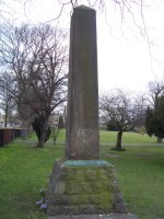
Obelisk at Gravesend
- Status:
Extant
- Type:
-
- National grid reference:
TQ6551674281
- Location:
NW of the Thames and Medway Canal Basin
- Location map at Streetmap:
TQ6551674281
- Original 19th century parish:
Milton-next-Gravesend
- Depicted on first edition of OS 6" map as:
[not marked]
- Moved:
Yes
- Circumstances of move:
Moved to act as a memorial commemorating the gift to the Corporation of
Gravesend of the pleasure ground and foreshore by C M Arnold Esq, Mayor 1890-1893.
See Benson's A history of Gravesend; or,
A historical perambulation of Gravesend and Northfleet.
- New national grid reference:
TQ6540774116
- New location:
At SE corner of Gordon Gardens, near to the gate at the junction of Ordnance Road,
Khartoum Place, and Canal Road
- Map of new location at Streetmap:
TQ6540774116
- Locality:
Gravesend
- Access:
When gardens open to public
- Listed building:
Grade II
- Local authority:
Gravesham
- Last seen:
15/03/2010
- Date missing:
n/a
- Notes:
Originally erected in 1826 to replace a tree which formerly marked boundary
(see Cruden's The history of the town of
Gravesend in the county of Kent, and of the port of London pp 36-37).
The obelisk has no inscription relating to the coal duties or to the Port of London, only a plaque on the
plinth recording the gift of Gordon Gardens to the town.
Additional photographs of obelisk at Gravesend:
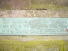
Plaque on obelisk
at Gravesend in 2010

Former site of obelisk
at Gravesend in 2010
Link to photographs of obelisk at Gravesend
Back up to Individual boundary marks
Page created by Martin Nail: Contact me. Last revised
8th April 2010
 This
web site: Copyright © 2010 Martin Nail. It is licensed under a Creative Commons
Attribution-Non-Commercial-Share Alike 2.0 UK: England & Wales License.
This
web site: Copyright © 2010 Martin Nail. It is licensed under a Creative Commons
Attribution-Non-Commercial-Share Alike 2.0 UK: England & Wales License.
 |
|
 |
|