You are here: City posts —>
The boundary marks today —>
Individual boundary marks —>
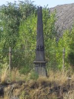
Obelisk 206
- Status:
Extant
- Type:
4b
- National grid reference:
TQ5047168142
- Location:
N side of railway 80 m W of Swanley Bypass
- Location map at Streetmap:
TQ5047168142
- Original 19th century parish:
St Mary Cray
- Depicted on first edition of OS 6" map as:
Pillar
- Moved:
No
- Circumstances of move:
n/a
- New national grid reference:
n/a
- New location:
n/a
- Map of new location at Streetmap:
n/a
- Locality:
Swanley
- Access:
On railway land but visible from public footpath on opposite side of railway
- Listed building:
Grade II
- Local authority:
Sevenoaks
- Last seen:
16/08/2010
- Date missing:
n/a
- Notes:
Photograph on Ideal Homes website:
City of London Coal
Duty Boundary Mark, Cray Valley, 1938
Additional photographs of Obelisk 206:

Obelisk 206 in 2008

Inscription on
Obelisk 206 in 2010
Link to photographs of Obelisk 206
<— Previous mark |
Back up to Individual boundary marks |
Next mark —>
Page created by Martin Nail: Contact me. Last revised
18th August 2018
 This
web site: Copyright © 2018 Martin Nail. It is licensed under a Creative Commons
Attribution-Non-Commercial-Share Alike 2.0 UK: England & Wales License.
This
web site: Copyright © 2018 Martin Nail. It is licensed under a Creative Commons
Attribution-Non-Commercial-Share Alike 2.0 UK: England & Wales License.
 |
|
 |
|