You are here: City posts —>
The boundary marks today —>
Individual boundary marks —>
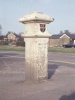
Post 176
- Status:
Extant
- Type:
2
- National grid reference:
TQ3654158248
- Location:
W side of Chelsham Road at junction with Limpsfield Road
- Location map at Streetmap:
TQ3654158248
- Original 19th century parish:
Warlingham
- Depicted on first edition of OS 6" map as:
City Pt
- Moved:
Yes
- Circumstances of move:
Moved when supermarket built on site of bus garage in 1994
- New national grid reference:
TQ3647258268
- New location:
N side of Limpsfield Road outside supermarket 70 m W of roundabout at junction with Chelsham Road
- Map of new location at Streetmap:
TQ3647258268
- Locality:
Warlingham
- Access:
Beside road
- Listed building:
Grade II
- Local authority:
Tandridge
- Last seen:
15/06/2008
- Date missing:
n/a
- Notes:
Additional photographs of Post 176:
Post 176 in 1972

Post 176 in 1972
Link to photographs of Post 176
<— Previous mark |
Back up to Individual boundary marks |
Next mark —>
Page created by Martin Nail: Contact me. Last revised
24th January 2010
 This
web site: Copyright © 2010 Martin Nail. It is licensed under a Creative Commons
Attribution-Non-Commercial-Share Alike 2.0 UK: England & Wales License.
This
web site: Copyright © 2010 Martin Nail. It is licensed under a Creative Commons
Attribution-Non-Commercial-Share Alike 2.0 UK: England & Wales License.
 |
|
 |
|