You are here: City posts —>
The boundary marks today —>
Individual boundary marks —>
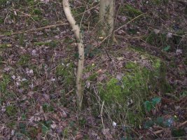
Obelisk 173
- Status:
Extant
- Type:
5
- National grid reference:
TQ3530957036
- Location:
N side of railway on S side of Stuart Road, 35 m from Woldingham Road (plinth only remains)
- Location map at Streetmap:
TQ3530957036
- Original 19th century parish:
Warlingham
- Depicted on first edition of OS 6" map as:
[not marked]
- Moved:
No
- Circumstances of move:
n/a
- New national grid reference:
n/a
- New location:
n/a
- Map of new location at Streetmap:
n/a
- Locality:
Woldingham
- Access:
On railway land but visible from road
- Listed building:
Not listed
- Local authority:
Tandridge
- Last seen:
08/03/2009
- Date missing:
n/a
- Notes:
Obelisk missing by 1983 but plinth remains (08/03/2009). Shaft had been removed from base between 1966 and 1972.
Additional photographs of Obelisk 173:

Obelisk 173 in 1966
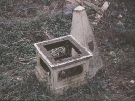
Obelisk 173 in 1972
Link to photographs of Obelisk 173
<— Previous mark |
Back up to Individual boundary marks |
Next mark —>
Page created by Martin Nail: Contact me. Last revised
24th January 2010
 This
web site: Copyright © 2010 Martin Nail. It is licensed under a Creative Commons
Attribution-Non-Commercial-Share Alike 2.0 UK: England & Wales License.
This
web site: Copyright © 2010 Martin Nail. It is licensed under a Creative Commons
Attribution-Non-Commercial-Share Alike 2.0 UK: England & Wales License.
 |
|
 |
|