You are here: City posts —>
The boundary marks today —>
Individual boundary marks —>
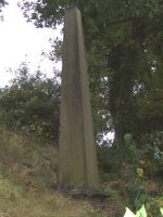
Obelisk 102
- Status:
Extant
- Type:
4b
- National grid reference:
TQ1402765799
- Location:
N side of railway next to No 100 Douglas Road
- Location map at Streetmap:
TQ1402765799
- Original 19th century parish:
Thames Ditton
- Depicted on first edition of OS 6" map as:
Obelisk
- Moved:
No
- Circumstances of move:
n/a
- New national grid reference:
n/a
- New location:
n/a
- Map of new location at Streetmap:
n/a
- Locality:
Esher
- Access:
On railway land but visible from road
- Listed building:
Grade II
- Local authority:
Elmbridge
- Last seen:
24/10/2007
- Date missing:
n/a
- Notes:
Additional photographs of Obelisk 102:

Coat of arms on Obelisk 102 in 1972
Link to photographs of Obelisk 102
<— Previous mark |
Back up to Individual boundary marks |
Next mark —>
Page created by Martin Nail: Contact me. Last revised
15th August 2010
 This
web site: Copyright © 2010 Martin Nail. It is licensed under a Creative Commons
Attribution-Non-Commercial-Share Alike 2.0 UK: England & Wales License.
This
web site: Copyright © 2010 Martin Nail. It is licensed under a Creative Commons
Attribution-Non-Commercial-Share Alike 2.0 UK: England & Wales License.
 |
|
 |
|