You are here: City posts —>
The boundary marks today —>
Individual boundary marks —>
Post 80
- Status:
Missing
- Type:
2e
- National grid reference:
TQ0248075570
- Location:
S side of Horton Road 500 m W of junction with Poyle Road (site now under Wraysbury Reservoir)
- Location map at Streetmap:
TQ0248075570
- Original 19th century parish:
Stanwell
- Depicted on first edition of OS 6" map as:
City Post
- Moved:
Yes
- Circumstances of move:
Moved in 1966 when Wraysbury Reservoir constructed
- New national grid reference:
TQ0259775726
- New location:
S side of Horton Road, as realigned, 500 m W of junction with Poyle Road
- Map of new location at Streetmap:
TQ0259775726
- Locality:
Poyle
- Access:
None
- Listed building:
Not listed
- Local authority:
Slough
- Last seen:
1993
- Date missing:
by 2007
- Notes:
Said to have been uprooted and later stolen
Additional photographs of Post 80:
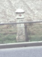
Post 80 in 1963

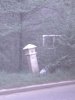
Site of Post 80 in 2010
Link to photographs of Post 80
<— Previous mark |
Back up to Individual boundary marks |
Next mark —>
Page created by Martin Nail: Contact me. Last revised
30th August 2010
 This
web site: Copyright © 2010 Martin Nail. It is licensed under a Creative Commons
Attribution-Non-Commercial-Share Alike 2.0 UK: England & Wales License.
This
web site: Copyright © 2010 Martin Nail. It is licensed under a Creative Commons
Attribution-Non-Commercial-Share Alike 2.0 UK: England & Wales License.
 |
|
 |
|