You are here: City posts —>
The boundary marks today —>
Individual boundary marks —>
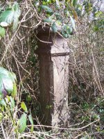
Post 61
- Status:
Extant
- Type:
2e
- National grid reference:
TQ0435093501
- Location:
N bank of River Colne, W of Shire Ditch, E of easternmost point of Inns Lake
- Location map at Streetmap:
TQ0435093501
- Original 19th century parish:
Harefield
- Depicted on first edition of OS 6" map as:
City Post
- Moved:
No
- Circumstances of move:
n/a
- New national grid reference:
n/a
- New location:
n/a
- Map of new location at Streetmap:
n/a
- Locality:
Rickmansworth
- Access:
On private land but visible from permissive footpath on other bank of river
- Listed building:
Not listed
- Local authority:
Hillingdon
- Last seen:
09/03/2009
- Date missing:
n/a
- Notes:
Re-erected 09/05/1964 by Rickmansworth Historical Society after being recovered from Shire Ditch
Additional photographs of Post 61:
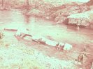
Post 61 in 1964
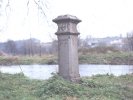
Post 61 in 1972
Link to photographs of Post 61
<— Previous mark |
Back up to Individual boundary marks |
Next mark —>
Page created by Martin Nail: Contact me. Last revised
19th May 2010
 This
web site: Copyright © 2010 Martin Nail. It is licensed under a Creative Commons
Attribution-Non-Commercial-Share Alike 2.0 UK: England & Wales License.
This
web site: Copyright © 2010 Martin Nail. It is licensed under a Creative Commons
Attribution-Non-Commercial-Share Alike 2.0 UK: England & Wales License.
 |
|
 |
|