You are here: City posts —>
The boundary marks today —>
Individual boundary marks —>
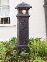
Post 5
- Status:
Extant
- Type:
2d
- National grid reference:
TQ4844988679
- Location:
E side of Whalebone Lane North at NW corner of grounds of Warren Comprehensive School
- Location map at Streetmap:
TQ4844988679
- Original 19th century parish:
Dagenham
- Depicted on first edition of OS 6" map as:
[not marked]
- Moved:
Yes
- Circumstances of move:
Moved following road widening in 1960
- New national grid reference:
TQ4804486532
- New location:
On display outside Valence House Museum, Valence Park, Becontree Avenue, to left of front door
- Map of new location at Streetmap:
TQ4804486532
- Locality:
Dagenham
- Access:
During museum opening hours
- Listed building:
Not listed
- Local authority:
Barking and Dagenham
- Last seen:
13/07/2010
- Date missing:
n/a
- Notes:
Additional photographs of Post 5:

Post 5 in 1972

Post 5 in 2007

Original site of
Post 5 in 2010
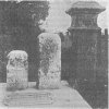
Post 5 in 1910
Link to photographs of Post 5
<— Previous mark |
Back up to Individual boundary marks |
Next mark —>
Page created by Martin Nail: Contact me. Last revised
10th October 2010
 This
web site: Copyright © 2010 Martin Nail. It is licensed under a Creative Commons
Attribution-Non-Commercial-Share Alike 2.0 UK: England & Wales License.
This
web site: Copyright © 2010 Martin Nail. It is licensed under a Creative Commons
Attribution-Non-Commercial-Share Alike 2.0 UK: England & Wales License.
 |
|
 |
|