You are here: City posts —>
The boundary marks today —>
Individual boundary marks —>
Post 75
- Status:
Extant
- Type:
2e
- National grid reference:
TQ0404876856
- Location:
On W bank of former course of Wyrardisbury River 200 m N of Madbridge (site now under M25 motorway)
- Location map at Streetmap:
TQ0404876856
- Original 19th century parish:
Stanwell
- Depicted on first edition of OS 6" map as:
City Post
- Moved:
Yes
- Circumstances of move:
Removed in 1982 in advance of construction of M25 motorway and at current location since 1998
- New national grid reference:
TQ0126994132
- New location:
On display at Chiltern Open Air Museum, Chalfont St. Giles
- Map of new location at Streetmap:
TQ0126994132
- Locality:
Chalfont St Giles
- Access:
When museum open
- Listed building:
Not listed
- Local authority:
Chiltern
- Last seen:
28/04/2008
- Date missing:
n/a
- Notes:
Correction plate previously attached to post also in Museum
Additional photographs of Post 75:

Post 75 in 1972
Post 75 in 1972
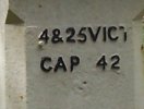
Inscription with 2 and part of T missing on Post No 75 in 2008
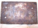
Correction plate from Post 75 in 2007
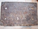
Rear view of correction plate from Post 75 in 2007

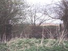
Site of Post 75 in 2010
Link to photographs of Post 75
<— Previous mark |
Back up to Individual boundary marks |
Next mark —>
Page created by Martin Nail: Contact me. Last revised
27th August 2010
 This
web site: Copyright © 2010 Martin Nail. It is licensed under a Creative Commons
Attribution-Non-Commercial-Share Alike 2.0 UK: England & Wales License.
This
web site: Copyright © 2010 Martin Nail. It is licensed under a Creative Commons
Attribution-Non-Commercial-Share Alike 2.0 UK: England & Wales License.
 |
|
 |
|

