You are here: City posts —>
The boundary marks today —>
Individual boundary marks —>
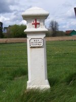
Post 74
- Status:
Extant
- Type:
2*
- National grid reference:
TQ0405676856
- Location:
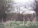
On E bank of former course of Wyrardisbury River 200 m N of Madbridge (site now under M25 motorway)
- Location map at Streetmap:
TQ0405676856
- Original 19th century parish:
Harmondsworth
- Depicted on first edition of OS 6" map as:
City Post
- Moved:
Yes
- Circumstances of move:
Removed in 1982 in advance of construction of M25 motorway and at current location since 1998
- New national grid reference:
TQ0092893845
- New location:
On display at Chiltern Open Air Museum, Chalfont St. Giles
- Map of new location at Streetmap:
TQ0092893845
- Locality:
Chalfont St Giles
- Access:
When museum open
- Listed building:
Not listed
- Local authority:
Chiltern
- Last seen:
28/04/2008
- Date missing:
n/a
- Notes:
Additional photographs of Post 74:
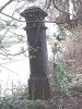
Post 74 in 1972
Post 74 in 1972

Site of Post 74 in 2010
Link to photographs of Post 74
<— Previous mark |
Back up to Individual boundary marks |
Next mark —>
Page created by Martin Nail: Contact me. Last revised
27th August 2010
 This
web site: Copyright © 2010 Martin Nail. It is licensed under a Creative Commons
Attribution-Non-Commercial-Share Alike 2.0 UK: England & Wales License.
This
web site: Copyright © 2010 Martin Nail. It is licensed under a Creative Commons
Attribution-Non-Commercial-Share Alike 2.0 UK: England & Wales License.
 |
|
 |
|