You are here: City posts —>
The boundary marks today —>
Individual boundary marks —>
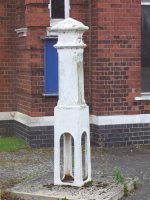
Post 100b
- Status:
Extant
- Type:
2e
- National grid reference:
TQ1341266845
- Location:
W of Island Barn Reservoir on E bank of former course of River Mole, 260 m NNE of divergence from River Ember
- Location map at Streetmap:
TQ1341266845
- Original 19th century parish:
East Molesey
- Depicted on first edition of OS 6" map as:
City Post
- Moved:
Yes
- Circumstances of move:
Moved in ca 1977
- New national grid reference:
TQ1175168305
- New location:
Inside gateway of Walton Advanced Water Treatment Works, Hurst Road
- Map of new location at Streetmap:
TQ1175168305
- Locality:
West Molesey
- Access:
On private land but visible from road
- Listed building:
Not listed
- Local authority:
Elmbridge
- Last seen:
24/10/2007
- Date missing:
n/a
- Notes:
<— Previous mark |
Back up to Individual boundary marks |
Next mark —>
Page created by Martin Nail: Contact me. Last revised
24th January 2010
 This
web site: Copyright © 2010 Martin Nail. It is licensed under a Creative Commons
Attribution-Non-Commercial-Share Alike 2.0 UK: England & Wales License.
This
web site: Copyright © 2010 Martin Nail. It is licensed under a Creative Commons
Attribution-Non-Commercial-Share Alike 2.0 UK: England & Wales License.
 |
|
 |
|