You are here: City posts —>
The boundary marks today —>
Individual boundary marks —>
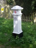
Post 51
- Status:
Extant
- Type:
2e*
- National grid reference:
TQ1060791690
- Location:
E side of Potter Street Hill, outside The Lodge 10 m N of junction with South View Road
- Location map at Streetmap:
TQ1060791690
- Original 19th century parish:
Pinner
- Depicted on first edition of OS 6" map as:
[not marked]
- Moved:
No
- Circumstances of move:
n/a
- New national grid reference:
n/a
- New location:
n/a
- Map of new location at Streetmap:
n/a
- Locality:
Pinner
- Access:
Beside road
- Listed building:
Grade II
- Local authority:
Harrow
- Last seen:
11/04/2008
- Date missing:
n/a
- Notes:
Stolen in 1994 but recovered and re-erected
<— Previous mark |
Back up to Individual boundary marks |
Next mark —>
Page created by Martin Nail: Contact me. Last revised
19th May 2010
 This
web site: Copyright © 2010 Martin Nail. It is licensed under a Creative Commons
Attribution-Non-Commercial-Share Alike 2.0 UK: England & Wales License.
This
web site: Copyright © 2010 Martin Nail. It is licensed under a Creative Commons
Attribution-Non-Commercial-Share Alike 2.0 UK: England & Wales License.
 |
|
 |
|