You are here: City posts —>
The boundary marks today —>
Individual boundary marks —>
Obelisk 45
- Status:
Extant
- Type:
4b
- National grid reference:
TQ1165796562
- Location:
W side of railway at five-arch viaduct, on S bank of River Colne
- Location map at Streetmap:
TQ1165796562
- Original 19th century parish:
Bushey
- Depicted on first edition of OS 6" map as:
[not marked]
- Moved:
Yes
- Circumstances of move:
Re-erected in 1984 after lying in pieces at original site since 1961
- New national grid reference:
TQ1164396578
- New location:
W side of railway at five-arch viaduct, N side of footpath on N bank of River Colne in Waterfields Recreation Ground
- Map of new location at Streetmap:
TQ1164396578
- Locality:
Watford
- Access:
On public footpath
- Listed building:
Grade II
- Local authority:
Watford
- Last seen:
16/11/2007
- Date missing:
n/a
- Notes:
Re-erection noted on plaque on ground in front of the obelisk
Additional photographs of Obelisk 45:
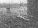
Obelisk 45 in 1972
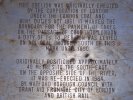
Plaque recording re-erection
of Obelisk 45
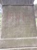
Remains of lettering on Obelisk 45 in 2008
Link to photographs of Obelisk 45
<— Previous mark |
Back up to Individual boundary marks |
Next mark —>
Page created by Martin Nail: Contact me. Last revised
15th August 2010
 This
web site: Copyright © 2010 Martin Nail. It is licensed under a Creative Commons
Attribution-Non-Commercial-Share Alike 2.0 UK: England & Wales License.
This
web site: Copyright © 2010 Martin Nail. It is licensed under a Creative Commons
Attribution-Non-Commercial-Share Alike 2.0 UK: England & Wales License.
 |
|
 |
|

