You are here: City posts —>
The boundary marks today —>
Individual boundary marks —>
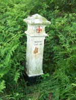
Post 144a
- Status:
Extant
- Type:
2e
- National grid reference:
TQ2346653511
- Location:
W side of Walton - Colley Hill bridlepath, on Banstead Heath 1370 m SE of Dorking Road
- Location map at Streetmap:
TQ2346653511
- Original 19th century parish:
Banstead
- Depicted on first edition of OS 6" map as:
City Post
- Moved:
No
- Circumstances of move:
n/a
- New national grid reference:
n/a
- New location:
n/a
- Map of new location at Streetmap:
n/a
- Locality:
Banstead Heath
- Access:
On public bridlepath
- Listed building:
Grade II
- Local authority:
Reigate and Banstead
- Last seen:
21/07/2010
- Date missing:
n/a
- Notes:
Additional information: why it is numbred 144a
Additional photographs of Post 144a:
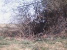
Post 144a in 1972
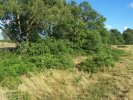
Post 144a and Post 145 in 2010
Link to photographs of Post 144a
<— Previous mark |
Back up to Individual boundary marks |
Next mark —>
Page created by Martin Nail: Contact me. Last revised
25th September 2010
 This
web site: Copyright © 2010 Martin Nail. It is licensed under a Creative Commons
Attribution-Non-Commercial-Share Alike 2.0 UK: England & Wales License.
This
web site: Copyright © 2010 Martin Nail. It is licensed under a Creative Commons
Attribution-Non-Commercial-Share Alike 2.0 UK: England & Wales License.
 |
|
 |
|