You are here: City posts —>
The boundary marks today —>
Individual boundary marks —>
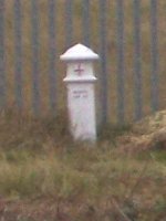
Post 101
- Status:
Extant
- Type:
2
- National grid reference:
TQ1374666652
- Location:
S of Island Barn Reservoir on N bank of former course of River Ember 420 m E of divergence from River Mole
- Location map at Streetmap:
TQ1374666652
- Original 19th century parish:
East Molesey
- Depicted on first edition of OS 6" map as:
City Post
- Moved:
Yes
- Circumstances of move:
Fell into the river during the 1968 floods but was rescued and reinstated [after 1972] following representations by the Esher District Local History Society (Baker 1989). Moved when river straightened as part of flood relief works in 1975-89
- New national grid reference:
TQ1379566621
- New location:
S of Island Barn Reservoir on N bank of current straightened course of the River Ember 400 m E of divergence from River Mole
- Map of new location at Streetmap:
TQ1379566621
- Locality:
West Molesey
- Access:
On private land
- Listed building:
Grade II
- Local authority:
Elmbridge
- Last seen:
24/10/2007
- Date missing:
n/a
- Notes:
OS MasterMap shows it in its old position
<— Previous mark |
Back up to Individual boundary marks |
Next mark —>
Page created by Martin Nail: Contact me. Last revised
7th February 2021
 This
web site: Copyright © 2021 Martin Nail. It is licensed under a Creative Commons
Attribution-Non-Commercial-Share Alike 2.0 UK: England & Wales License.
This
web site: Copyright © 2021 Martin Nail. It is licensed under a Creative Commons
Attribution-Non-Commercial-Share Alike 2.0 UK: England & Wales License.
 |
|
 |
|