You are here: City posts —>
The boundary marks today —>
Individual boundary marks —>
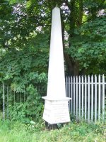
Obelisk 82
- Status:
Extant
- Type:
4d
- National grid reference:
TQ0180073800
- Location:
N side of railway E of stream 850 m SE of Coppermill Road
- Location map at Streetmap:
TQ0180073800
- Original 19th century parish:
Staines
- Depicted on first edition of OS 6" map as:
[not marked]
- Moved:
Yes
- Circumstances of move:
Re-erected in 1979
- New national grid reference:
TQ0262072024
- New location:
S side of Wraysbury Road opposite No 115, 30 m E of junction with Lammas Drive
- Map of new location at Streetmap:
TQ0262072024
- Locality:
Staines
- Access:
Beside road
- Listed building:
Not listed
- Local authority:
Windsor and Maidenhead
- Last seen:
18/08/2010
- Date missing:
n/a
- Notes:
Additional photographs of Obelisk 82:

Obelisk 82 in 1961

Obelisk 82 in 1966

Obelisk 82 in 1979

Inscription on Obelisk 82 in 2008
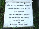
Plaque on Obelisk 82 in 2008

Obelisk 82 and Post 81 in 2008
Maker's name on Obelisk 82 in 1972
Link to photographs of Post 82
<— Previous mark |
Back up to Individual boundary marks |
Next mark —>
Page created by Martin Nail: Contact me. Last revised
27th August 2010
 This
web site: Copyright © 2010 Martin Nail. It is licensed under a Creative Commons
Attribution-Non-Commercial-Share Alike 2.0 UK: England & Wales License.
This
web site: Copyright © 2010 Martin Nail. It is licensed under a Creative Commons
Attribution-Non-Commercial-Share Alike 2.0 UK: England & Wales License.
 |
|
 |
|