You are here: City posts —>
The boundary marks today —>
Individual boundary marks —>
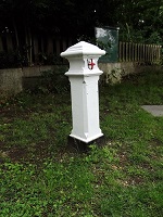
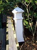
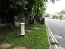
Post 46
- Status:
Moved
- Type:
2a
- National grid reference:
TQ1160996252
- Location:
S side of Water Lane, E of bridge over former course of River Colne
- Location map at Streetmap:
TQ1160996252
- Original 19th century parish:
Bushey
- Depicted on first edition of OS 6" map as:
City Post
- Moved:
Yes
- Circumstances of move:
Moved for road widening in 1966, and again in 2015
- New national grid reference:
TQ1161596252
- New location:
S side of Water Lane, 50 m E of bridge over River Colne
- Map of new location at Streetmap:
TQ1161596252
- Locality:
Watford
- Access:
Beside road
- Listed building:
Not listed
- Local authority:
Watford
- Last seen:
25/07/2015
- Date missing:
n/a
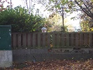
- Notes:
Moved for road widening in 1966 and placed outside a further education college. When the college was replaced by a supermarket the post was left the behind fence of supermarket car park. In 2015 the post was moved to the roadside verge.
Additional photographs of Post 46:

Post 46 in 1968
Post 41 in 2007
Post 41 in 2007
Post 41 in 2015
Link to photographs of Post 46
<— Previous mark |
Back up to Individual boundary marks |
Next mark —>
Page created by Martin Nail: Contact me. Last revised
18th August 2018
 This
web site: Copyright © 2018 Martin Nail. It is licensed under a Creative Commons
Attribution-Non-Commercial-Share Alike 2.0 UK: England & Wales License.
This
web site: Copyright © 2018 Martin Nail. It is licensed under a Creative Commons
Attribution-Non-Commercial-Share Alike 2.0 UK: England & Wales License.
 |
|
 |
|