You are here: City posts —>
The boundary marks today —>
Individual boundary marks —>
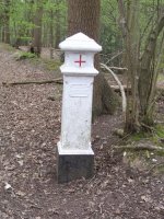
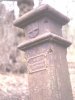
Post 24
- Status:
Extant
- Type:
2h
- National grid reference:
TL3227005766
- Location:
In Wormley Wood, 800 m NNW of Tanfield Farm
- Location map at Streetmap:
TL3227005766
- Original 19th century parish:
Cheshunt
- Depicted on first edition of OS 6" map as:
[not marked]
- Moved:
No
- Circumstances of move:
n/a
- New national grid reference:
n/a
- New location:
n/a
- Map of new location at Streetmap:
n/a
- Locality:
Wormley
- Access:
On permissive path in public access land
- Listed building:
Grade II
- Local authority:
Broxbourne
- Last seen:
03/04/2012
- Date missing:
n/a
- Notes:
Additional photographs of Post 24:

Post 24 in 2012

Post 24 in 2012

Post 24 in 1969
Post 24 in 1969
Post 24 in 1972

Post 24 in 2008
Link to photographs of Post 24
<— Previous mark |
Back up to Individual boundary marks |
Next mark —>
Page created by Martin Nail: Contact me. Last revised
15th April 2012
 This
web site: Copyright © 2012 Martin Nail. It is licensed under a Creative Commons
Attribution-Non-Commercial-Share Alike 2.0 UK: England & Wales License.
This
web site: Copyright © 2012 Martin Nail. It is licensed under a Creative Commons
Attribution-Non-Commercial-Share Alike 2.0 UK: England & Wales License.
 |
|
 |
|