You are here: City posts —>
The boundary marks today —>
Individual boundary marks —>
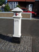
Post 4
- Status:
Extant
- Type:
2d
- National grid reference:
TQ4895788200
- Location:
S side of London Road outside No 403
- Location map at Streetmap:
TQ4895788200
- Original 19th century parish:
Dagenham
- Depicted on first edition of OS 6" map as:
B.P.
- Moved:
No
- Circumstances of move:
n/a
- New national grid reference:
n/a
- New location:
n/a
- Map of new location at Streetmap:
n/a
- Locality:
Dagenham
- Access:
Beside road
- Listed building:
Grade II
- Local authority:
Barking and Dagenham
- Last seen:
25/06/2008
- Date missing:
n/a
- Notes:
Restored 1991 -- plaque on pavement behind post
Additional photographs of Post 4:
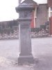
Post 4 in 1972

Maker's name
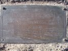
Plaque recording restoration
Link to photographs of Post 4
<— Previous mark |
Back up to Individual boundary marks |
Next mark —>
Page created by Martin Nail: Contact me. Last revised
24th January 2010
 This
web site: Copyright © 2010 Martin Nail. It is licensed under a Creative Commons
Attribution-Non-Commercial-Share Alike 2.0 UK: England & Wales License.
This
web site: Copyright © 2010 Martin Nail. It is licensed under a Creative Commons
Attribution-Non-Commercial-Share Alike 2.0 UK: England & Wales License.
 |
|
 |
|